Sunday, June 10, 2007
All work and no play makes John something something
Three days of very busy down time and tomorrow I'm back on the road headed south for TT-West. I'm looking forward to what should be just an awesome event and a fantastic week :) The roadtrip isn't quite over yet and the TT will probably see close to 2000 miles before I'm back home again. No rest for the wicked ;)
Friday, June 8, 2007
With Tired Eyes, Tired Minds, Tired Souls, We Slept
 I arrived back home this afternoon, about 2:30 after a short drive up from Russ's place in Southern Oregon. It was a bit odd driving familiar roads for a change, I had gotten used to seeing new places pretty much every mile I rolled. The house is still standing and the yard actually looks better than when I maintain it so I think I'll keep Brad on the payroll.
This turned out to be an epic trip, much more than I could have ever hoped for. I didn't really have a plan going in, just a basic list of places I wanted to visit and sort of let the timeline and route fall out as I drove. It was great seeing some spots again and others that were new to me. As much as I was able to see there's still so much that I want to go back and do. Next time I'm in Zion I am hiking to Angel's Landing :) The best parts of the trip were I think some of the spots that I least expected, some very good surprises along the way :)
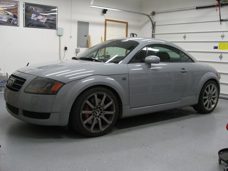
The TT was fantastic the entire way. It ate a MAF in Vermont but I had a spare and that was an easy swap in a parking lot, it was running fine with the dead one anyway. Many many bugs died (and a snake). It's a bit battered and bruised with a second crack in the windshield, a cracked lower front bumper and scuff marks from a tire impact and a door ding. It was great to be able to cruise at speed comfortably and then run mountain passes at speed or some intense twisties like the Dragon without ever having to think twice. Tomorrow the cleanup begins.
I can't wait to hit the road again, which is good because I've got another couple thousand miles next week for TT-West and my remaining vacation time :)
Some final stats:
36 days on the road
12,296 miles covered
28 states visited
21 hotels
~3500 pictures
410 gallons of gas consumed at $1400
~200 driving hours
Highest altitude: ~9900ft
Highest speed: 150mph :)
Final pics
Tuesday, June 5, 2007
TT Phone Home
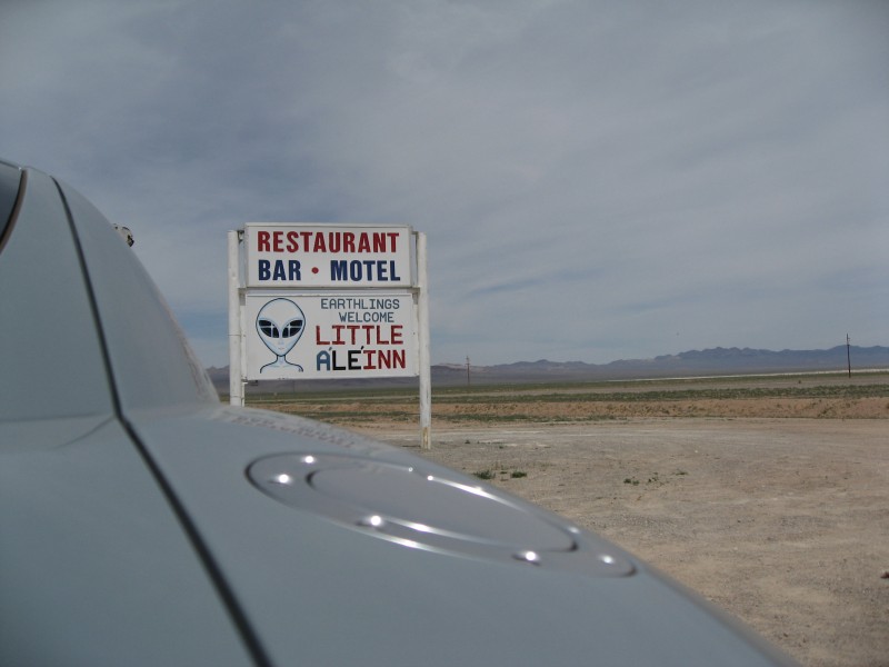
Today was the first long drive day (~9hrs) in over a week. I didn't really like Mapquest's advice on a route from Zion to Yosemite so I decided to throw my own together by running around the north side of Area 51 along the Extraterrestrial Highway and the town of Rachel. I figured any extra mileage would be offset by, ahem, higher average speeds.... I was right :)
The drive out of Springdale wasn't very much fun, I did not want to leave but I needed to start shrinking the miles to Portland so I headed off towards Yosemite. A quick drive down I-15 had me driving in Utah, cutting the corner of Arizona and then finally a quick drive in Nevada before I switched to secondary highways. The drive up 93 to 375 was pretty quick and 375 itself is mostly straight. I think it's about 90 miles total and half of that is made up of 3 straights that are ~15 miles long. The road seems to stretch out to infinity and no matter how fast you go the end stays way out on the horizon. Eventually I did hit the end of 375 and turned on to 6 which took me into California. Hwy 120 turned out to be very entertaining with several roller coaster grade dips that had massive compression at the bottoms before rotating the car and threatening to send it into orbit at each crest. I headed up the Tioga Pass from Lee Vining and into the park. The mountains had been getting closer all afternoon and now I was in them, the pass is at almost 10k feet.
I made it into the park having made exceptional time all day (78mph average speed) but then found out I had about 100 more miles to Oakhurst, about 3 more hours. I did get a first look at the park though and saw Half Dome and a few of the falls just while driving through. Having just been at Zion, Yosemite seemed to be a completely different planet. It's about the same elevation as Bryce but the geological formations are so completely different. It'll be fun to get a closer look tomorrow.
After driving several miles through some great twisties, at very slow speed with campers and trailers in the way, I finally made it to Oakhurst. I'll be spending two nights here before turning north for home. Hoping to get an early start tomorrow to beat the crowds but that never seems to work out too well ;)
A few pics from thedrive
Monday, June 4, 2007
Zion distilled
Today was my first day without having to drive anywhere in quite some time. I think the last time the TT was left parked for a full day was in NY and I'm not really sure that that's true either, it's possible this is the first day it's had off in a month. Yep, today makes one full month since I left my house and as I'm now within days of being back there I don't think I'm ready yet. Well, there are a few days left, and then TT-West and then perhaps another week of mischief :)
But anyway, back to Zion. I got everything together and hopped on the shuttle to the park and then caught the in-park shuttle to the Emerald Pools trailhead at the Lodge. I headed up and around clockwise this time, I think Russ and I started the other direction. It's a bit of an uphill walk but not too bad and the weather was perfect, clear blue skies and getting hot but not unbearable. I made it up to the middle pool and mistakenly thought it was the upper pool. Since I thought I was at the end of the trail I did what I usually do and started poking around for sidetrails :) I followed the water and started scrambling over rocks and boulders and eventually started climbing upwards... basically because there were rocks that went up the hill :) I popped out onto a trail and two people coming around the bend told me it was the trail to the upper pool, so I had bypassed all the switchbacks and just went straight up :)
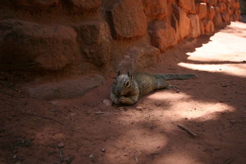
The upper pool was pretty crowded, a bunch of people in the water, it's deep enough in places to swim. I did manage a few unobstructed shots and a different take on the dangling foot picture too :) I continued down the trail and managed to get some decent hand-held long exposure shots of the cascade down to the lower pool. On the way back through I heard before I saw a squirrel lounging and munching on a snack. He didn't seem to mind being photographed, and at very close range too.
After the trail it was about lunchtime so I grabbed a sandwich at the lodge and finally got my chance to sit on lawn at the lodge and do nothing (besides eat) for awhile. There's lots of shade and a beautiful view and even when there are other people around it feels quiet. Next year I'm bringing a smoothie from Tsunami :)
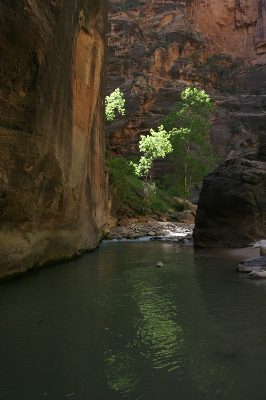
After lunch I hopped on the bus and headed to the Temple of Sinawava at the end of the park. I figured since it was warmer and I had climbed yesterday that I'd do the Narrows hike today. The trailhead really starts at the end of the river walk hike and that hike itself is a 2 mile round trip. There's lots to see along the way and the river walk is an easy mostly level walk. At the end of the walk you just hop in the river and keep going. I had already moved everything from pockets to backpack so all I needed to do was not get in past my waist or drop the camera ;) Most of the time the water is only ankle deep and sometimes just about waist deep. You can of course go in further if you want. The water felt great, not cold at all and for the first time I was hiking without sweating constantly :) I headed upriver for about an hour and a half, maybe two hours so I think I made it at least 2 miles in, probably further. The Narrows really captures everything about Zion in one place, the river, trees and red cliffs and you're right in the middle of it all.
Unfortunately my late start had me chasing the sun and it seemed to always just be around the next corner, need to start this hike earlier in the day. I reluctantly turned back as there wasn't enough light for my lenses and was starting to get breezy. I also wanted to catch the sunset at the Temple so I needed to get back. The hike back is always quicker than the hike in and I was back to the river walk trailhead by I think 6pm.
I wandered around the Temple of Sinawava for a bit taking pictures and decided I wasn't really tired yet and since it was my last day I wanted to make the most of it. There's a trail that runs along the river pretty much from the Temple all the way to the visitor center so I headed to the river and started walking that back to the next bus stop (Big Bend). They don't allow cars in the park past the lodge so there was no outside noise except for the occasional bus running up on the road. The sun was already low enough that the canyon at this point was out of direct light but that only seemed to make the colors that much more saturated. I didn't really have any idea how far it was between the two stops and they don't pick up people in between (maybe if you ask real nice) so I was sort of committed to the full walk :) I think it's probably about a mile given how long it took to get there. It was a great way to end the day though and I think some day I would like to walk the entire length of the park.
I hopped on a bus and started heading out but as I got further out of the park there was still alot of light left in the canyon so I hopped off a few times to take pictures and then caught the next bus coming down the trail. Eventually I was at the visitor center and reluctantly grabbed a bus back to the hotel. I think a return trip will be sooner rather than later, maybe even this fall sometime (I hope :)
I had heard good things about the meatloaf at the restaurant at the Driftwood Inn (right across the street from where I was staying) so I headed there for dinner. Fantastic food with a table outside and a great view as the sun set capped off two of the best days ever. The Narrows was a unique hike and was alot of fun but the Hidden Canyon hike on the first day was still just so much better. I could have spent hours on that perch high above the valley.
It's not quite the end of the trip yet but I think this quote from American Beauty sums up the past month...
"...it's hard to stay mad, when there's so much beauty in the world. Sometimes I feel like I'm seeing it all at once, and it's too much, my heart fills up like a balloon that's about to burst... And then I remember to relax, and stop trying to hold on to it, and then it flows through me like rain and I can't feel anything but gratitude for every single moment of my stupid little life."
Zion Day 2
Saturday, June 2, 2007
Z(omg)ion

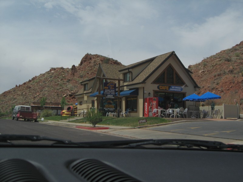
It's a very short drive from Bryce down to Zion, only about 60 miles. I rolled into Springdale, the town outside the park, in time for lunch. Russ and I had stopped at a great cafe called Tsunami just outside the park so I stopped in for a wrap and smoothie. I couldn't check into the hotel until 3 so I planned on hitting the park right away. Springdale/Zion have things figured out. They run a shuttle through the town into the park, and then another shuttle loop within the park. I was able to park the TT at the hotel and get the shuttle right across the street, very convenient. Before I hopped on the shuttle I had some camera bag mods to do. Since the hikes were going to be longer and I wouldn't be able to reload water at the car I wanted to have more with me in the park. I picked up a mesh water bottle bag at an outfitters store and was able to zip-tie it to the camera bag :)
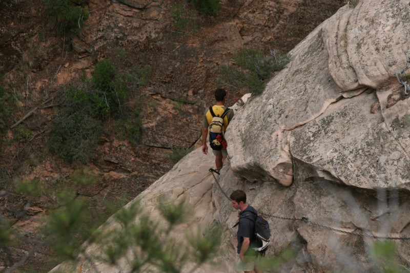
So that taken care of, and after remembering to put sunscreen on, I was off to the park. You switch to the park shuttle at the visitor center and heading further into the park it was like Christmas morning, I couldn't wait to get in and start hiking, somewhere, anywhere! :) Russ and I had done a few easy hikes last year and I thought the Weeping Rock trail would be a good warm up. It's a short hike with a bit of a climb on the way in, nothing too tough. After returning from that I noticed another trailhead there, the Hidden Canyon trail. The trailguide said it was strenuous with an 850ft climb and a 2mile round trip. Seemed good to me :)
By the time I finished the main switchbacks I was pretty beat, it's a steep trail. Then things get more interesting with a narrow trail on slickrock and a very steep dropoff to the right. They do give you chains to hang on to tho so that's nice. This pic gives a good idea of what this part of the trail is like. The white rock is the trail, the red rock beyond is really beyond.
Soon after that you reach the hidden canyon and the maintained trail ends. The trail continues but it's mainly sand and some scrambling over boulders and trees. I went as far as I could on that part of the trail, maybe another mile, but eventually got to some large boulders that would have been difficult to cross on my own. I actually took that picture hanging off another boulder that was in my path. Maybe next time :)
The hidden canyon was great though. There was a ton of interesting sandstone formations to take pictures of and it was absolutely quiet. There were two other guys up there but they were always out of view and I couldn't hear them. You could hear lots of critters running around in the forest, birds, chipmunks and lizards.
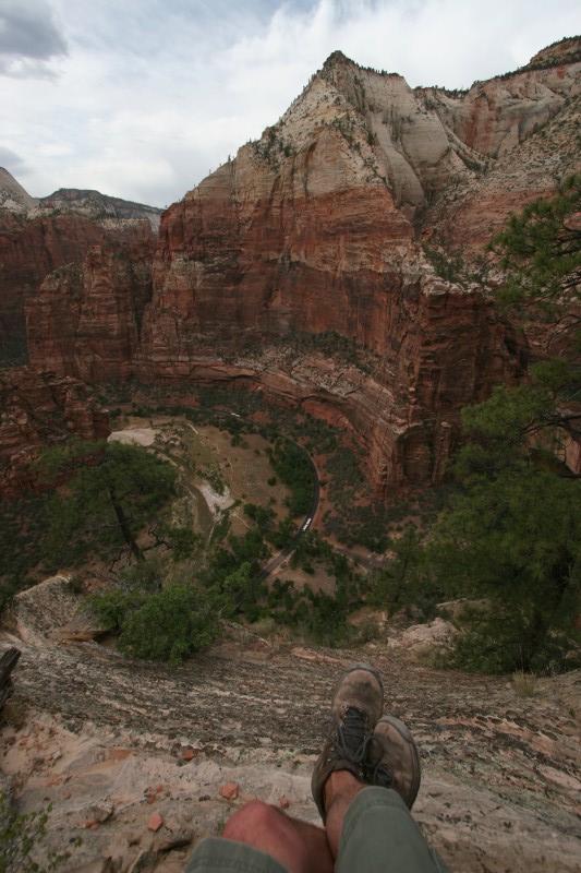
Just before I started back down the switchbacks at the end of the hidden canyon I noticed a side trail headed up. Hmmm, have to see where that goes :) This dangling leg shot will be hard to top (literally), I think I was about 900ft above the canyon floor on that perch :) You can see the park shuttle on the road below.
The hike back down was much quicker, I think less than an hour from when I left my perch. I think I was on the trail for about 5hrs so that was pretty much all I did in the park today. I did head down to the river for a bit and two deer came through the bushes about 30ft away from me. I moved back downstream from them a bit and got a few pictures of them enjoying dinner then hopped on the shuttle and back to town to finally check in.
I'm not sure which trails I'll end up on tomorrow. Angel's Landing is tempting but it's a 1500ft climb. There's also the Narrows hike which goes down the river, and the Emerald Pools and a bunch of others. 1500ft would be an awfully good leg dangling pic though :)
all of the pics
Friday, June 1, 2007
Bryce
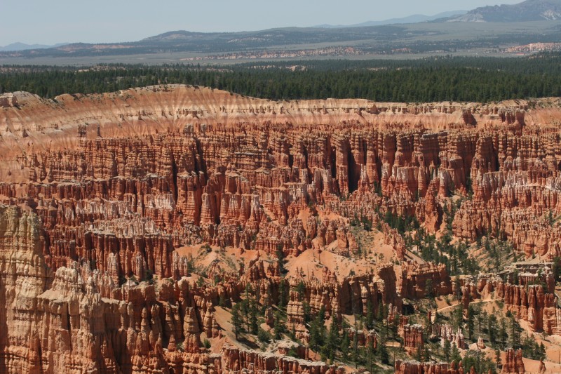
I left right on time today (so another late start ;) and headed from Torrey down to Bryce. It's a straight shot down Hwy12, about 112 miles. The stretch between Torrey and Escalante is one of the best roads I've ever driven.... very twisty, lots of elevation change (9400 ft summit) and serious drop-offs. At one point the road stretches right across the top of a peak with steep drops on both sides of the road. Good times :) I managed to make the trip at a 60mph average which is a bit higher than mapquest had predicted. I grabbed lunch right outside the park and then headed for the visitor center.
Danielle had recommended the Navajo Loop as a pretty short hike with good views but it's been closed since May 23 last year due to a rockslide. You can hike about 1/4 mile of the trail down to the canyon floor which did give much better views of the rocks than just shooting down on them. The trail back up is a pretty good climb and by the top I was pretty much done with hiking for the day. Hiking at 8k ft, the heat and being tired from yesterday had wiped me out so I stuck with drives to the scenic overlooks and short walks down trails for better views but no long hikes. Bryce is a busy park though and is setup for driving tours so the overlooks are actually pretty good. I need to head back at some point when I have more energy to do some of the longer trails, I'd love to hike down to the canyon floor.
I spent about 4hrs in the park before heading off Hwy14 for Cedar City. This was another entertaining drive but more traffic and not quite as twisty as 12. Still it was a pretty short drive into town and I made it in early enough to get a real sit down meal at Crapplebees. Tomorrow I'm off to Zion for a couple days of hiking and relaxation :)
pics from Bryce
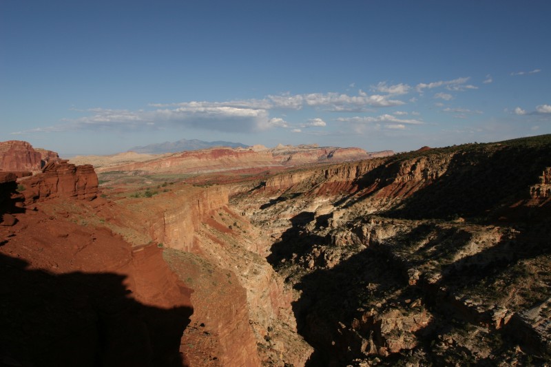
Capitol Reef
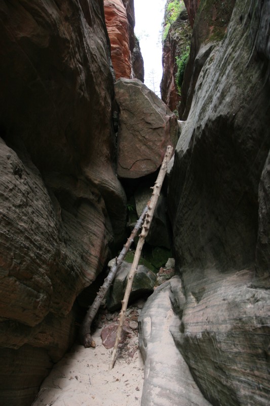
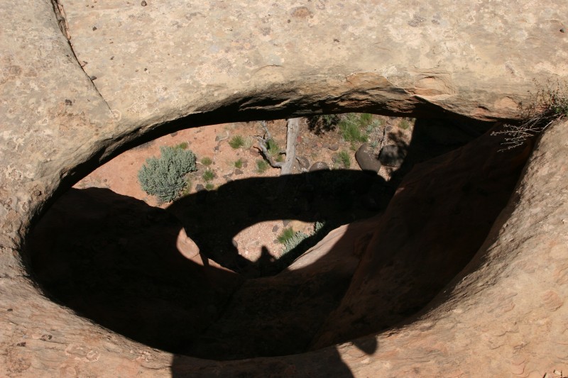
Another late start today but it's just a short 5 mile drive into the park. I stopped at the visitor center to get a trail guide and get some recommendations on good hikes. The park ranger suggested the Cohab Canyon trail and the Grand Wash trail. I started off at the Cohab Trail and decided against hiking to the Hickman Bridge since I had seen Arches yesterday. Cohab was supposed to be a moderate trail with a pretty steep start and then views of a hidden canyon and the valley below. I got lost a few times but was able to backtrack and get back onto the trail. On one sidetrip I came across a large hole in the stone with a thin natural bridge hanging out over the ground below. It was pretty cool to find but a reminder to watch your step :)
After hiking for awhile I was starting to get a bit tired and it looked like the trail headed up a pretty steep slope around to the right. I was just about ready to turn back but figured I'd see just where the trail headed and it went around to the left and revealed a large balanced rock that you could climb all over. The top of the trail wasn't too far beyond that point and there were some great views all around. I had met a guy from Washington earlier on the trail and he was on his way back when I got to the top (the trail continued on for a bit). He had been on the road since February and had a few more weeks left on the road, a true road warrior.
The hike back down much easier and I took a few detours to explore a bit off trail. Lots of rock formations and wildflowers all around. I think the round trip was probably about 4 miles.
I headed around to the scenic drive where the Grand Wash trailhead was located. It was a few miles down a dirt track road so I got to do some rally driving on the way in :) The Grand Wash hike was to some narrows in the middle of the wash, about a 2 mile round trip. Unfortunately (or fortunately) I didn't check the map for details and hiked beyond the narrows and almost all the way to the other side of the park. By the time I got back I think I had walked about 4 miles instead of 2. There were some cool cliffs beyond the narrows so it was worth the hike in but I was hoping to get back to the small store in the park for some home made ice cream and a Weinhard's Orange Cream soda and it was getting late. I did a very fast pace walk back to the beginning of the trail and made it to the store right at closing time. I was exhausted from the hike and crashed on the stairs with the ice cream and soda :)
I wanted to get sunset pictures but had a few hours to kill so I went back to the hotel to recover from the hikes and get some laundry done. Around 6:30 I headed back to the park and hiked up to Sunset Point which had a great view of the Fremont River gorge below and mountains for off to the east. I set up camp on a ledge and relaxed watching the sunset and taking pics as the sun went down. I stayed a bit too late though and by the time I made it back to the hotel the restaurant was closed and pretty much everything in town was too. I made a pretty good dinner of wheat thins, trail mix and ben & jerrys :)
So except for the lack of food and running out of water a couple times it was a fantastic day. Capitol Reef seems to go largely unnoticed among the other parks in the area and is very lightly traveled. There are many more hikes, petroglyphs, the river, fruit orchards and two large sections of the park I didn't even get to. Definitely need to make a return trip back here too :)
Capitol Reef pics
Subscribe to:
Posts (Atom)