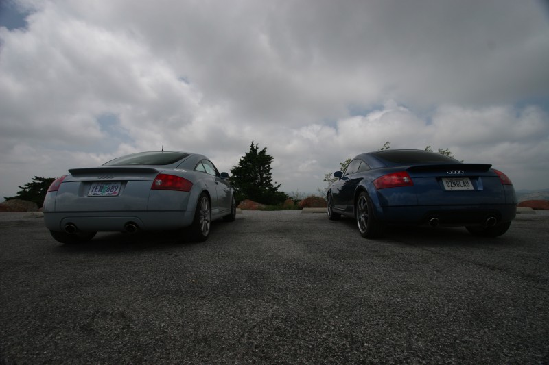
Sunday, June 10, 2007
All work and no play makes John something something
Three days of very busy down time and tomorrow I'm back on the road headed south for TT-West. I'm looking forward to what should be just an awesome event and a fantastic week :) The roadtrip isn't quite over yet and the TT will probably see close to 2000 miles before I'm back home again. No rest for the wicked ;)
Friday, June 8, 2007
With Tired Eyes, Tired Minds, Tired Souls, We Slept
 I arrived back home this afternoon, about 2:30 after a short drive up from Russ's place in Southern Oregon. It was a bit odd driving familiar roads for a change, I had gotten used to seeing new places pretty much every mile I rolled. The house is still standing and the yard actually looks better than when I maintain it so I think I'll keep Brad on the payroll.
This turned out to be an epic trip, much more than I could have ever hoped for. I didn't really have a plan going in, just a basic list of places I wanted to visit and sort of let the timeline and route fall out as I drove. It was great seeing some spots again and others that were new to me. As much as I was able to see there's still so much that I want to go back and do. Next time I'm in Zion I am hiking to Angel's Landing :) The best parts of the trip were I think some of the spots that I least expected, some very good surprises along the way :)
The TT was fantastic the entire way. It ate a MAF in Vermont but I had a spare and that was an easy swap in a parking lot, it was running fine with the dead one anyway. Many many bugs died (and a snake). It's a bit battered and bruised with a second crack in the windshield, a cracked lower front bumper and scuff marks from a tire impact and a door ding. It was great to be able to cruise at speed comfortably and then run mountain passes at speed or some intense twisties like the Dragon without ever having to think twice. Tomorrow the cleanup begins.
I can't wait to hit the road again, which is good because I've got another couple thousand miles next week for TT-West and my remaining vacation time :)
Some final stats:
36 days on the road
12,296 miles covered
28 states visited
21 hotels
~3500 pictures
410 gallons of gas consumed at $1400
~200 driving hours
Highest altitude: ~9900ft
Highest speed: 150mph :)
Final pics
Tuesday, June 5, 2007
TT Phone Home
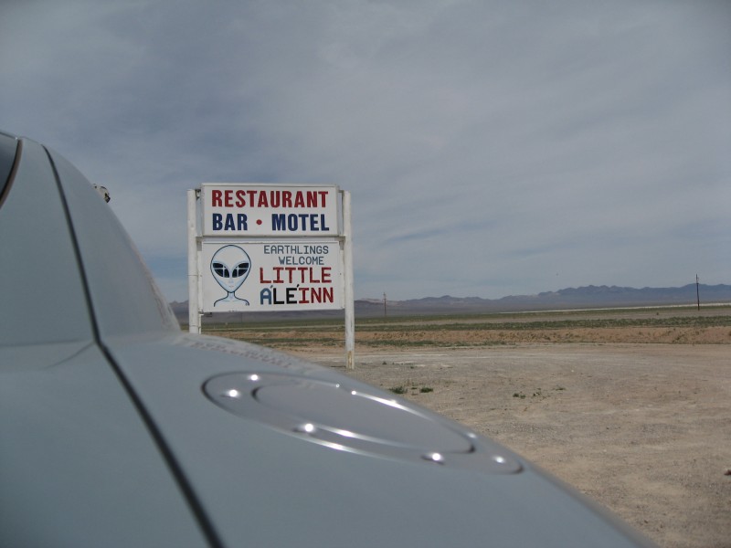
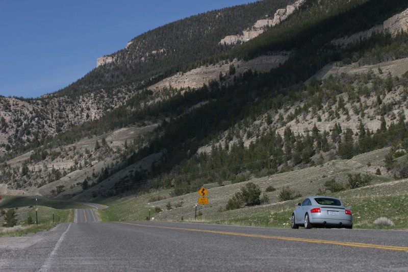
Today was the first long drive day (~9hrs) in over a week. I didn't really like Mapquest's advice on a route from Zion to Yosemite so I decided to throw my own together by running around the north side of Area 51 along the Extraterrestrial Highway and the town of Rachel. I figured any extra mileage would be offset by, ahem, higher average speeds.... I was right :)
The drive out of Springdale wasn't very much fun, I did not want to leave but I needed to start shrinking the miles to Portland so I headed off towards Yosemite. A quick drive down I-15 had me driving in Utah, cutting the corner of Arizona and then finally a quick drive in Nevada before I switched to secondary highways. The drive up 93 to 375 was pretty quick and 375 itself is mostly straight. I think it's about 90 miles total and half of that is made up of 3 straights that are ~15 miles long. The road seems to stretch out to infinity and no matter how fast you go the end stays way out on the horizon. Eventually I did hit the end of 375 and turned on to 6 which took me into California. Hwy 120 turned out to be very entertaining with several roller coaster grade dips that had massive compression at the bottoms before rotating the car and threatening to send it into orbit at each crest. I headed up the Tioga Pass from Lee Vining and into the park. The mountains had been getting closer all afternoon and now I was in them, the pass is at almost 10k feet.
I made it into the park having made exceptional time all day (78mph average speed) but then found out I had about 100 more miles to Oakhurst, about 3 more hours. I did get a first look at the park though and saw Half Dome and a few of the falls just while driving through. Having just been at Zion, Yosemite seemed to be a completely different planet. It's about the same elevation as Bryce but the geological formations are so completely different. It'll be fun to get a closer look tomorrow.
After driving several miles through some great twisties, at very slow speed with campers and trailers in the way, I finally made it to Oakhurst. I'll be spending two nights here before turning north for home. Hoping to get an early start tomorrow to beat the crowds but that never seems to work out too well ;)
A few pics from thedrive
Monday, June 4, 2007
Zion distilled
Today was my first day without having to drive anywhere in quite some time. I think the last time the TT was left parked for a full day was in NY and I'm not really sure that that's true either, it's possible this is the first day it's had off in a month. Yep, today makes one full month since I left my house and as I'm now within days of being back there I don't think I'm ready yet. Well, there are a few days left, and then TT-West and then perhaps another week of mischief :)
But anyway, back to Zion. I got everything together and hopped on the shuttle to the park and then caught the in-park shuttle to the Emerald Pools trailhead at the Lodge. I headed up and around clockwise this time, I think Russ and I started the other direction. It's a bit of an uphill walk but not too bad and the weather was perfect, clear blue skies and getting hot but not unbearable. I made it up to the middle pool and mistakenly thought it was the upper pool. Since I thought I was at the end of the trail I did what I usually do and started poking around for sidetrails :) I followed the water and started scrambling over rocks and boulders and eventually started climbing upwards... basically because there were rocks that went up the hill :) I popped out onto a trail and two people coming around the bend told me it was the trail to the upper pool, so I had bypassed all the switchbacks and just went straight up :)
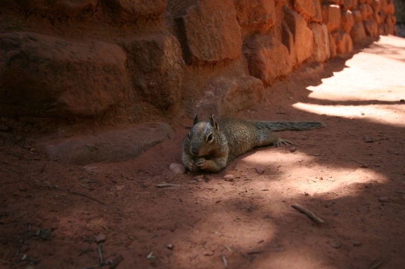
The upper pool was pretty crowded, a bunch of people in the water, it's deep enough in places to swim. I did manage a few unobstructed shots and a different take on the dangling foot picture too :) I continued down the trail and managed to get some decent hand-held long exposure shots of the cascade down to the lower pool. On the way back through I heard before I saw a squirrel lounging and munching on a snack. He didn't seem to mind being photographed, and at very close range too.
After the trail it was about lunchtime so I grabbed a sandwich at the lodge and finally got my chance to sit on lawn at the lodge and do nothing (besides eat) for awhile. There's lots of shade and a beautiful view and even when there are other people around it feels quiet. Next year I'm bringing a smoothie from Tsunami :)
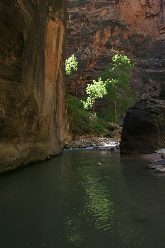
After lunch I hopped on the bus and headed to the Temple of Sinawava at the end of the park. I figured since it was warmer and I had climbed yesterday that I'd do the Narrows hike today. The trailhead really starts at the end of the river walk hike and that hike itself is a 2 mile round trip. There's lots to see along the way and the river walk is an easy mostly level walk. At the end of the walk you just hop in the river and keep going. I had already moved everything from pockets to backpack so all I needed to do was not get in past my waist or drop the camera ;) Most of the time the water is only ankle deep and sometimes just about waist deep. You can of course go in further if you want. The water felt great, not cold at all and for the first time I was hiking without sweating constantly :) I headed upriver for about an hour and a half, maybe two hours so I think I made it at least 2 miles in, probably further. The Narrows really captures everything about Zion in one place, the river, trees and red cliffs and you're right in the middle of it all.
Unfortunately my late start had me chasing the sun and it seemed to always just be around the next corner, need to start this hike earlier in the day. I reluctantly turned back as there wasn't enough light for my lenses and was starting to get breezy. I also wanted to catch the sunset at the Temple so I needed to get back. The hike back is always quicker than the hike in and I was back to the river walk trailhead by I think 6pm.
I wandered around the Temple of Sinawava for a bit taking pictures and decided I wasn't really tired yet and since it was my last day I wanted to make the most of it. There's a trail that runs along the river pretty much from the Temple all the way to the visitor center so I headed to the river and started walking that back to the next bus stop (Big Bend). They don't allow cars in the park past the lodge so there was no outside noise except for the occasional bus running up on the road. The sun was already low enough that the canyon at this point was out of direct light but that only seemed to make the colors that much more saturated. I didn't really have any idea how far it was between the two stops and they don't pick up people in between (maybe if you ask real nice) so I was sort of committed to the full walk :) I think it's probably about a mile given how long it took to get there. It was a great way to end the day though and I think some day I would like to walk the entire length of the park.
I hopped on a bus and started heading out but as I got further out of the park there was still alot of light left in the canyon so I hopped off a few times to take pictures and then caught the next bus coming down the trail. Eventually I was at the visitor center and reluctantly grabbed a bus back to the hotel. I think a return trip will be sooner rather than later, maybe even this fall sometime (I hope :)
I had heard good things about the meatloaf at the restaurant at the Driftwood Inn (right across the street from where I was staying) so I headed there for dinner. Fantastic food with a table outside and a great view as the sun set capped off two of the best days ever. The Narrows was a unique hike and was alot of fun but the Hidden Canyon hike on the first day was still just so much better. I could have spent hours on that perch high above the valley.
It's not quite the end of the trip yet but I think this quote from American Beauty sums up the past month...
"...it's hard to stay mad, when there's so much beauty in the world. Sometimes I feel like I'm seeing it all at once, and it's too much, my heart fills up like a balloon that's about to burst... And then I remember to relax, and stop trying to hold on to it, and then it flows through me like rain and I can't feel anything but gratitude for every single moment of my stupid little life."
Zion Day 2
Saturday, June 2, 2007
Z(omg)ion

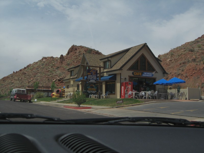
It's a very short drive from Bryce down to Zion, only about 60 miles. I rolled into Springdale, the town outside the park, in time for lunch. Russ and I had stopped at a great cafe called Tsunami just outside the park so I stopped in for a wrap and smoothie. I couldn't check into the hotel until 3 so I planned on hitting the park right away. Springdale/Zion have things figured out. They run a shuttle through the town into the park, and then another shuttle loop within the park. I was able to park the TT at the hotel and get the shuttle right across the street, very convenient. Before I hopped on the shuttle I had some camera bag mods to do. Since the hikes were going to be longer and I wouldn't be able to reload water at the car I wanted to have more with me in the park. I picked up a mesh water bottle bag at an outfitters store and was able to zip-tie it to the camera bag :)
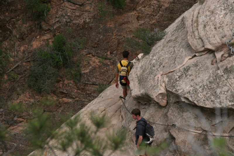
So that taken care of, and after remembering to put sunscreen on, I was off to the park. You switch to the park shuttle at the visitor center and heading further into the park it was like Christmas morning, I couldn't wait to get in and start hiking, somewhere, anywhere! :) Russ and I had done a few easy hikes last year and I thought the Weeping Rock trail would be a good warm up. It's a short hike with a bit of a climb on the way in, nothing too tough. After returning from that I noticed another trailhead there, the Hidden Canyon trail. The trailguide said it was strenuous with an 850ft climb and a 2mile round trip. Seemed good to me :)
By the time I finished the main switchbacks I was pretty beat, it's a steep trail. Then things get more interesting with a narrow trail on slickrock and a very steep dropoff to the right. They do give you chains to hang on to tho so that's nice. This pic gives a good idea of what this part of the trail is like. The white rock is the trail, the red rock beyond is really beyond.
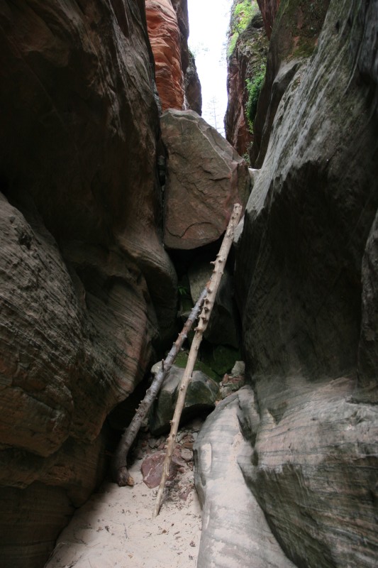
Soon after that you reach the hidden canyon and the maintained trail ends. The trail continues but it's mainly sand and some scrambling over boulders and trees. I went as far as I could on that part of the trail, maybe another mile, but eventually got to some large boulders that would have been difficult to cross on my own. I actually took that picture hanging off another boulder that was in my path. Maybe next time :)
The hidden canyon was great though. There was a ton of interesting sandstone formations to take pictures of and it was absolutely quiet. There were two other guys up there but they were always out of view and I couldn't hear them. You could hear lots of critters running around in the forest, birds, chipmunks and lizards.
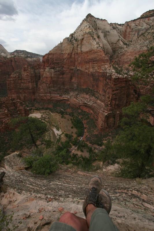
Just before I started back down the switchbacks at the end of the hidden canyon I noticed a side trail headed up. Hmmm, have to see where that goes :) This dangling leg shot will be hard to top (literally), I think I was about 900ft above the canyon floor on that perch :) You can see the park shuttle on the road below.
The hike back down was much quicker, I think less than an hour from when I left my perch. I think I was on the trail for about 5hrs so that was pretty much all I did in the park today. I did head down to the river for a bit and two deer came through the bushes about 30ft away from me. I moved back downstream from them a bit and got a few pictures of them enjoying dinner then hopped on the shuttle and back to town to finally check in.
I'm not sure which trails I'll end up on tomorrow. Angel's Landing is tempting but it's a 1500ft climb. There's also the Narrows hike which goes down the river, and the Emerald Pools and a bunch of others. 1500ft would be an awfully good leg dangling pic though :)
all of the pics
Friday, June 1, 2007
Bryce
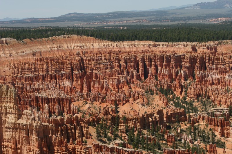
I left right on time today (so another late start ;) and headed from Torrey down to Bryce. It's a straight shot down Hwy12, about 112 miles. The stretch between Torrey and Escalante is one of the best roads I've ever driven.... very twisty, lots of elevation change (9400 ft summit) and serious drop-offs. At one point the road stretches right across the top of a peak with steep drops on both sides of the road. Good times :) I managed to make the trip at a 60mph average which is a bit higher than mapquest had predicted. I grabbed lunch right outside the park and then headed for the visitor center.
Danielle had recommended the Navajo Loop as a pretty short hike with good views but it's been closed since May 23 last year due to a rockslide. You can hike about 1/4 mile of the trail down to the canyon floor which did give much better views of the rocks than just shooting down on them. The trail back up is a pretty good climb and by the top I was pretty much done with hiking for the day. Hiking at 8k ft, the heat and being tired from yesterday had wiped me out so I stuck with drives to the scenic overlooks and short walks down trails for better views but no long hikes. Bryce is a busy park though and is setup for driving tours so the overlooks are actually pretty good. I need to head back at some point when I have more energy to do some of the longer trails, I'd love to hike down to the canyon floor.
I spent about 4hrs in the park before heading off Hwy14 for Cedar City. This was another entertaining drive but more traffic and not quite as twisty as 12. Still it was a pretty short drive into town and I made it in early enough to get a real sit down meal at Crapplebees. Tomorrow I'm off to Zion for a couple days of hiking and relaxation :)
pics from Bryce
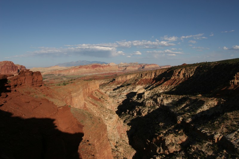
Capitol Reef
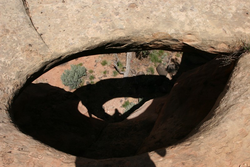
Another late start today but it's just a short 5 mile drive into the park. I stopped at the visitor center to get a trail guide and get some recommendations on good hikes. The park ranger suggested the Cohab Canyon trail and the Grand Wash trail. I started off at the Cohab Trail and decided against hiking to the Hickman Bridge since I had seen Arches yesterday. Cohab was supposed to be a moderate trail with a pretty steep start and then views of a hidden canyon and the valley below. I got lost a few times but was able to backtrack and get back onto the trail. On one sidetrip I came across a large hole in the stone with a thin natural bridge hanging out over the ground below. It was pretty cool to find but a reminder to watch your step :)
After hiking for awhile I was starting to get a bit tired and it looked like the trail headed up a pretty steep slope around to the right. I was just about ready to turn back but figured I'd see just where the trail headed and it went around to the left and revealed a large balanced rock that you could climb all over. The top of the trail wasn't too far beyond that point and there were some great views all around. I had met a guy from Washington earlier on the trail and he was on his way back when I got to the top (the trail continued on for a bit). He had been on the road since February and had a few more weeks left on the road, a true road warrior.
The hike back down much easier and I took a few detours to explore a bit off trail. Lots of rock formations and wildflowers all around. I think the round trip was probably about 4 miles.
I headed around to the scenic drive where the Grand Wash trailhead was located. It was a few miles down a dirt track road so I got to do some rally driving on the way in :) The Grand Wash hike was to some narrows in the middle of the wash, about a 2 mile round trip. Unfortunately (or fortunately) I didn't check the map for details and hiked beyond the narrows and almost all the way to the other side of the park. By the time I got back I think I had walked about 4 miles instead of 2. There were some cool cliffs beyond the narrows so it was worth the hike in but I was hoping to get back to the small store in the park for some home made ice cream and a Weinhard's Orange Cream soda and it was getting late. I did a very fast pace walk back to the beginning of the trail and made it to the store right at closing time. I was exhausted from the hike and crashed on the stairs with the ice cream and soda :)
I wanted to get sunset pictures but had a few hours to kill so I went back to the hotel to recover from the hikes and get some laundry done. Around 6:30 I headed back to the park and hiked up to Sunset Point which had a great view of the Fremont River gorge below and mountains for off to the east. I set up camp on a ledge and relaxed watching the sunset and taking pics as the sun went down. I stayed a bit too late though and by the time I made it back to the hotel the restaurant was closed and pretty much everything in town was too. I made a pretty good dinner of wheat thins, trail mix and ben & jerrys :)
So except for the lack of food and running out of water a couple times it was a fantastic day. Capitol Reef seems to go largely unnoticed among the other parks in the area and is very lightly traveled. There are many more hikes, petroglyphs, the river, fruit orchards and two large sections of the park I didn't even get to. Definitely need to make a return trip back here too :)
Capitol Reef pics
Thursday, May 31, 2007
Walking among giants

It was a short 6 mile drive from the hotel in Moab down to Arches National Park. The view from the highway heading into the park gives no hints about what you're about to see. It's carved through the same red rock that is everywhere out here but once you start the climb into the actual park it goes up a couple notches. The initial views are very impressive, huge sheer cliff faces, rock formations and small arches visible on the way in. The first overlook/trail is at the Windows. I drove through there and it was absolutely packed. I did actually find a parking spot but I didn't like it, too many people, so I checked the guidebook and found a more difficult hike and headed there instead. Harder hikes usually mean less people. The hike out to Delicate Arch is 3 miles and there's a 480ft climb, this is at about 5k ft as opposed to 6k at Canyon de Chelly so I figured it'd be easy ;) I finally remembered everything too, camera gear, water, sunscreen and a couple granola bars. The hike out is boring. At Canyon de Chelly there were at least some really interesting views that became visible as you traversed the trail. The Delicate Arch trail is pretty much all exposed slickrock, only a couple of spots with shade and not alot of photo worthy stops. You don't get to see the arch until the very end of the trail, you come around a bend and it's there. There was a group under it when I got there so I had to wait a bit to get some clear pics of it. The arch is at the edge of a cliff with a bowl cut out below it so you can still kind of get behind it to shoot up underneath it.
The hike back out was almost all downhill and much faster. From there I headed deeper into the park to go see Landscape Arch. This was a shorter hike, I think only 2 miles, and less elevation gain. There were also two side hikes to go see Tunnel Arch and Pine Tree Arch. This was a great hike because you're down on the valley floor with these huge rock formations towering over you. There are incredible views in all directions and way off in the distance there are snow capped mountains providing a beautiful backdrop. Lots of blooming cactii and interesting trees to take pictures of too. Apparently Delicate Arch used to be Landscape Arch but somebody swapped the names on a map by accident and it stuck. After seeing the current Landscape Arch it makes sense, there's not much landscape behind it and it looks like a thin ribbon of rock arcing across the sky. In 1991 a 60ft chunk fell off so no more hiking underneath it so it was difficult to get good pictures with the sun behind it. The trail continues beyond Landscape Arch to a couple other arches but it is more difficult and it was getting late in the day.
On the way back out I stopped off at the Windows again and it was much less crowded and the sun was at a lower angle so the light was getting better too. My first stop was at Turret Arch and you could get right under this one and to both sides so it was great to take pics of.
I continued over to the South Window (I may be turned around here, could have been the North Window) and there was no one else around so I was able to spend quite a bit of time here taking pictures. I think this was my favorite spot of the day and I was glad I waited to see it. It's absolutely massive when you're standing below it and the sky was so blue and the line along the rock so crisp that it all seemed surreal. There's a primitive trail that hikes around the backside of the windows and back to the parking lots. I was hoping to get under the North Window from there but it doesn't quite work that way. There were still some great views along the way though.
After Arches it was back in the car for the short hop to Torrey which is just outside Capitol Reef. The drive down Hwy24 is now in my top 5 favorite drives ever. Incredible scenery (when I could see it before the bugs attacked) and a great road. Then you get into the park and it was about 6:30 so the sun was getting low and I really think it was as good as driving through Yellowstone. I'm looking forward to checking out the rest of the park and I'll be staying for sunset pictures instead of motoring off to Bryce. Unfortunately it looks like the really good stuff is only accessible by 4wd vehicles and I don't think they mean a TT with quattro. We'll see how far I can get though :)
Wednesday, May 30, 2007
Canyon de Chelly

Another late start today. Eating dinner at 10pm meant I didn't fall asleep until 3am. I woke up around 9 and was on the road at 10. It was just a short drive (about 2hrs) from Kayenta to Chinle down 163 and 191. Russ had tipped me off to Canyon de Chelly (pronounced shay) and I didn't really know anything about it or what it looked like but Russ hasn't steered me wrong yet so I figured it'd be worth a look while I was in the neighborhood. It's a bit of an odd park. There are two rim drives, north and south, which are run by the national park service. The actual valley floor (and some property on the rim) are still Navajo Tribal land. To get to the valley floor you need a guide, except for one trail.
I decided to start at the south rim and that turned out to be the right choice. A few overlooks in is the White House Ruins overlook. This is the start of a 2.5 mile (round trip) hike down to the valley floor to the White House Ruins, this is the only way down on your own. I figured I'd take advantage of the opportunity and headed off. I remembered to bring water today but I forgot to put on sunscreen (clear blue sky, sun high overhead, no shade). The hike down took about 45 minutes (I think) with switchbacks down the side of the canyon wall, fairly narrow in places. The views on the way down are spectacular. As you descend the angles change and more of the valley floor becomes visible. Once down to the floor there's a short hike out to the ruins. They're tucked into caves at the base of this imposing sheer wall. There were some kids playing in the creek near the ruins and the splashing and laughter was echoing from the walls and sounded like they were coming from the ruins, it was a bit eerie.
After taking a bunch of pics and resting a bit I started back up the hill. I thought it had taken 45 minutes to come down (seemed about right for 1.25 miles) so I was expecting a long climb out. The first time I stopped for rest (gasping for air, this place is over 6k feet up) I had been walking up the trail for 10 minutes. I made it up a few more switchbacks and took another break, 17 minutes. Then I passed a spot that I thought I remembered seeing right at the beginning and sure enough a few more switchbacks up and I was back at the top. I'm not sure how I mixed up the times but it seemed like a much shorter walk out than the walk down. Temps at the top were pretty cool (80s) and there was a good breeze blowing so I took some time to cool off and catch my breath. My legs were so tired that I stalled the car backing out of the parking space :)
I continued down the path all the way to the Spider Rock Overlook which is the last spot on the south rim drive. There are two rock spires that stand in the middle of the valley floor next to a stream. In the distance is a volcanic core. I stopped at the Sliding Rock Overlook on the way back out and got the best dangling feet shot of the trip so far. That's 700ft straight down to a farm below and just an incredible view of the valley below.
It was almost 4pm by now and I had a 200 mile drive to Moab ahead of me so I left the park without visiting the north rim drive. Russ, thanks for the heads up, it was well worth the trip and I can't wait to get back! :)
It took about 3hrs to get up to Moab, a pretty nice town but more bike shops than restaurants. Tomorrow I'm off to Arches and maybe Capitol Reef. I'm already booked for a hotel at Capitol Reef so I can do that tomorrow or Thursday. Bryce and Zion are up after that.
The full gallery.
Monday, May 28, 2007
Good days eventually oxidize

Today was a good day. A tip from a photographer in the Grand Canyon yesterday led me to one of the most beautiful places I've ever seen, the Horseshoe Bend Overlook of the Colorado River just outside of Page. But before I get ahead of myself, the scenery along the highways out here is incredible. The drive from Flagstaff up to Page on 89 and then on to Kayenta on 98 and 160 feels like driving inside the Grand Canyon. There's a mountain pass just after the 89alt split that is carved straight through the rock. There's so much to see and it just never gets old. You never know what kind of landscape you'll get around each bend. It's also fun to watch the subtle shifts as you traverse a couple hundred miles.
Anyway, back to the Horseshoe Overlook. There's a bit of a hike to get to it (1.5 miles roundtrip), it only took about 45 minutes. The catch is the climb back out is up a soft sandy slope, and it's at 4200ft. I took several opportunities to catch one last look before continuing up the slope :) The overlook itself is impressive, you look down on the Colorado River, several hundred feet down carved out of the red rock. Along the river banks there's a bunch of vegetation so you've got greens and reds and the sky today was unreal, a perfect deep blue. Well worth the effort to get out to see it and I had timed it just right so when I got there there were only 2 other people at the overlook. On the way out a busload of people was coming down the trail.
A Park Ranger at the Horseshoe Bend had tipped me off to the Glen Canyon Dam overlook behind the park service headquarters so that was my next stop. The view here is quite good too. There were a few boats out on the river and someone fly-fishing. I'd love to know where you get the tour boats from because they were down around the Bend too.
After that I got on to the reason I had come to Page in the first place, Antelope Canyon. I found the sign for it at Hwy98 (there IS a sign ;) and got on a 1pm tour to the upper canyon. It's a short ride down a dry riverbed (not so dry when there are flash floods) to the canyon opening. It's a very cool place to visit, a narrow slot canyon carved out of the sandstone. Lots of interesting views looking straight up at how the wind and water have made their way through the rock. I would have liked to have more time for pictures (and less people) so I'll be making a return trip at some point. I'd be going back for another look anyway :)
I motored on from Page to Kayenta and got checked in to the hotel around 5:30. I had hoped to make it into town with enough time to head to Monument Valley and it worked out perfectly. I had done the drive through the Valley last year but this time I planned to keep it a bit simpler (and less abusive to the TT) and just shoot the sunset from the visitor center. The sky was very clear and there was great light into the valley except for one short cloud layer that briefly dimmed the show. I have been hoping to get some sunset shots somewhere on this trip and wasn't disappointed with the show this evening. Watching the light change and the shadows crawling across the valley floor as the sun went down, it would be hard to improve on that finish to today.
All of the pics. It's getting harder and harder to pic out which ones to post.
Trip Stats:
322 miles
5hrs 20 minutes of driving
61mph average speed
32mpg
12k ft climbed
one stop for gas (with a bunch of dogs wandering around the gas station)
Sunday, May 27, 2007
Today's theme: Big holes in the ground

I continued west on I-40 today crossing into Arizona this morning after driving through some storms over the continental divide. Thunderstorms with lots of lightning at 8am seem strange to me. You can watch storms develop way off in the distance out here and they become as much a part of the scenery as the landscape itself. It usually doesn't take long to drive through them and the lightning is impressive.
The first hole in the ground today was the Meteor Crater near Winslow. I skipped the guided tour but did hit the observation viewpoints. It's a big hole :) Some interesting stuff in the museum too but pretty much an in and out stop. Oh, one thing to mention though, the altitude. I'm not sure where I picked it all up, I know I was around 4k ft at White Sands and last night I thought the car wasn't running right and I checked and I was still well over 6k ft. Today going up and down all the stairs at the Meteor Crater at around 7k ft had me wiped out quickly. It'll be so nice to get into Death Valley with some nice, dense, atmosphere :)
From the crater I hopped back on 40 west for Flagstaff and then 64 north to the second big hole for the day, the Grand Canyon. I knew it would be packed since it's Memorial Day weekend but the drive into the park was ridiculous. I was almost ready to turn around and have a nice day off at the hotel but I kept heading east and the crowds thinned once I got away from Mather Point. The rest of the viewpoints were busy but there was still lots of parking and when I hiked way out to the edge there were very few people. You've got to get close to the edge at the Grand Canyon, if you stay up by the parking lot and fence you're missing out. Besides, it's always fun to go climb over rocks :)
I headed all the way to the east entrance and got gas because I was getting pretty close to empty and then hit all the viewpoints on the way back. I spent quite awhile at The Grand Viewpoint, just hanging out with my legs dangling over the edge. I had a hotel booked in Flagstaff 90 minutes away so around 5pm I headed out.
Flagstaff seems pretty nice but
tomorrow I'll be rolling out north for the next stops, this will be as far west as I get for awhile as I'll be heading back east and up and around Utah's Canyonlands. I think I've got about a week left on the road now and still a bunch of stuff to see.
Grand Canyon pictures
Saturday, May 26, 2007
Getting serious now

Today was a busy day, a full tour of Central New Mexico with multiple stops ranging from a huge national park to just a sign on the side of the road. I was also back to my usual early start routine, back on the road by 7:30am. I started out backtracking a bit heading to Artesia from Carlsbad. From there I turned west on Hwy82 to Alamogordo. This was a fantastic road, starts out a bit dull but gets more interesting with curves in all the right places as it heads to over 8500 ft at the city of Cloudcroft. The descent back down the otherside drops about 4k ft and gives a few peeks at White Sands in the distance.
From Alamogordo I turned south for White Sands and the TT hit a major milestone. The drive through the park is kind of like the Badlands but different, and blinding. 15 minutes out of the car and I think I was sunburnt. I wasn't really sure what to do to make the pics interesting since it's all just bright white sand so I did what I usually do and put the TT in the middle of the frame, I think it worked out well :)
After a quick loop and a few pics I headed back out of the park and continued north on 54 past Tularosa on my way to Hwy380. 380 incidentally is the road I came into Roswell on, all the way from Decatur the day before.
380 had my second scenic waypoint of the day, the Trinity historic marker. I didn't know where on 380 it was and thought I had missed it and then finally spotted it about 15 miles east of the I25 junction.
I turned back north at Socorro on I25 after crossing a little more than halfway across New Mexico. Did I mention that I really like New Mexico? Except for the bad gas and boring scenery east of Roswell it's a beautiful state, good drivers, roads and real speed limits :) Anyway, I-25 brought me all the way up to Albuquerque, keeping me out of storms that were building to the east and west the whole afternoon. Albuquerque had my third spot for the day, the Petroglyph National Monument on the west side of town. Albuquerque looks to be a really nice town too. I'd like to spend some more time there and maybe sample Santa Fe at some point. The Petroglyphs were a bit meh, I guess I was expecting too much. Still managed a few interesting pics before continuing west on I40.
A short drive on I40 got me to Hwy117 and my final stop for the day, El Malpais National Monument where La Ventana, a natural arch rock formation, is located. Clouds were rolling in and it was starting to get a bit dark but it's still an impressive sight. I'm not sure I'll be able to make it to Arches so I figured I try to see as many of the other arch formations as possible :)
I had hoped to make it to the Arizona border today for a short hop to the Grand Canyon but that was over an hour away so I stopped off in Grants at a Holiday Inn Express. Tomorrow the plan is to see Meteor Crater on the way to the Grand Canyon. Of course since it's Memorial Day weekend everything is booked so I'm spending tomorrow night all the way in Flagstaff. I should still get half a day tomorrow and Monday morning at the Canyon before heading back east for a bit :)
Full gallery from today
Trip Stats:
525 miles
8.5hrs of driving
61mph average speed
30mpg
17k ft climbed
two gas stops
Nundarground
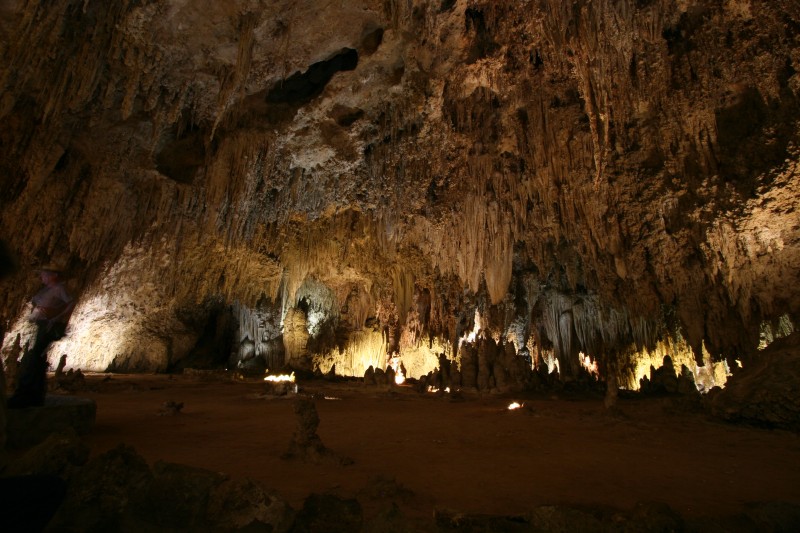
I think I survived the night without being abducted by aliens or the locals. First thing I headed over to the local UFO museum for a quick walkthrough of the exhibits there. Not really too much I hadn't already seen on any number of Discovery channel shows but still pretty cool to see it firsthand. From there I hopped back in the weather balloon and headed south towards Carlsbad and the caverns below. I must mention that Roswell holds the record for worst gas of the drive, even with several thousand miles left I don't think anyone else will top $3.60/gallon for 90 octane :(
The drive south on 285 was pretty short and I rolled into the park around 1:30. I grabbed a ticket for the King's Palace tour and hopped on the elevator for the 750ft descent. The caves are incredible and I'm so glad Danielle talked me into going (and reminded me to take the tripod). The King's Palace tour is guided so you get to hear some of the history of how the caves were found and how the park has evolved over the years (no elevators back at the beginning). They also turn all the lights out to give you and idea of what Jim White had to deal with when he was first exploring the caves. After the King's Palace I did the hike through the Big Room eventually spending about 4hrs underground. I didn't take too many pictures since I had to do 15-20 second exposures due to the limited light.
From the caverns I headed back north into the town of Carlsbad for the Best Western I had booked. A pretty short day and early to bed for the long day scheduled tomorrow.
Carlsbad Caverns pics
Trip Stats:
130 miles
2.5hrs of driving
55mph average speed
30mpg
2900 ft climbed
one gas stop
Thursday, May 24, 2007
Back in the west
The last few days have gotten me from North Carolina to Roswell, NM. In between I spent a few days visiting a friend in Oklahoma. The drive after the Dragon was much much more boring. There are a few interesting sights in Arkansas but IMO it should be avoided at all costs.
Oklahoma was mostly what I expected it to be until Danielle took me out to the Wichita Mountains Wildlife Refuge. Beautiful scenery, twisty roads, mountains, lakes, all sorts of wildlife. We had a great time touring the area starting at Mt Scott, grabbing awesome burgers at Meers (vanilla RC!), hiking around the lakes and visiting the hidden gem of the entire park, the Holy City. Some of the wildlife cooperated with the pics, the prairie dogs and geese all seemed to like the cameras (and the TTs), the buffalo however didn't seem to like us, or me anyway. We didn't hang around the rattlesnake long enough to find out what he thought. We wrapped up the day with sodas and fried peaches back at Meers. It was only a couple day visit but Danielle and her family (even the dogs) all made me feel so welcome that it seemed like I stop by to visit all the time.
This morning I rolled out of Oklahoma and experienced some driving that made the Dragon look like an easy commute, a half hour driving through a Texoma storm system will get your pulse up a bit. After clearing the weather I headed west on 380 from Decatur all the way to Roswell passing through a bunch of tiny Texas towns. Tomorrow I'll be at the UFO museum and then off to Carlsbad Caverns in southern NM.
Pics from Oklahoma
Trip Stats:
8451 miles
24 states
273 gallons of gas
Sunday, May 20, 2007
Tail of the Dragon

After a quick stop at the Modshack (thanks again Susan and Steve!) I was finally headed back west with a detour planned at the Tail of the Dragon. North Carolina is a large state when driven east to west, it's about 400 miles from the Shack to the Dragon. It's a nice state for cruising though, beautiful scenery, wildflowers, decent speeds and not too much traffic. I did hook up with a silver 180 FWD coupe for a bit but he was traveling at speeds too rich for my blood so I dropped back to a conservative 7 over. Thanks for the entertainment though! The landscape changes pretty dramatically as you get further west and start climbing into the Smoky Mountains. Not a really serious climb but it's nice to do some mountain passes again.
Early in the afternoon I headed off of I-40 and headed for US 129 where the Tail of the Dragon is. I got a bit sidetracked off of US19 and was on US23/74 but it was headed in the right direction and was scenic enough. Once I turned onto 129 the traffic thinned out and things started getting more interesting. I rolled over 98,000 miles just at the beginning of 129.
The Dragon itself is absolutely bizarre, insane and intense. I still don't understand how it exists, I guess it's the closest thing to the Ring that we have. I was in local traffic with sport bikes darting in and out trying to get free, go around a corner and there's the Killboy crew taking pictures, go around the next bend and there's emergency equipment a wrecked bike and a guy strapped to a stretcher. In fact as I came up to the start of the Dragon traffic was stopped for a wreck and I saw 3 people on stretchers, lots of wrecked bikes and tons of ambulances and police along the 11 mile stretch. I thought they'd shut it down for wrecks but it's just like a local caution. I did get a couple of spots without any traffic and was able to really run hard and it was intense. It's very tight, lots of 2nd and 3rd gear stuff, lots of camber. The TT is really good in these conditions, WOT acceleration out of the tight corners, quattro doing its thing and rocketing into the next bend. The Stoptechs got a workout too :) I thought about doing a couple runs but the steady stream of ambulances and police cars headed southbound made me think twice so I continued on to I-40. It was fun and I'm glad I made the stop but I don't think I'll head back. Way too much traffic and bikes, people running beyond their limits. It is the most intense 11 miles (318 turns) I've driven but some of the twisties out in Oregon aren't too far behind and are alot safer.
After the Dragon I continued west on 40 and eventually made it west of Nashville, taking advantage of the time zone change west of Knoxville. I should be in good shape for tomorrow, another 700 miles and I'll be in Oklahoma.
Trip Stats:
700 miles
11hrs of driving
65mph average speed
30mpg
27k ft climbed
three gas stops
On the road again

Not sure if I couldn't wait to get on the road again but Saturday morning I started the return trip, although I'm still not pointed in the right direction. I spent a week in Kingston and had a great time relaxing and spending time with the family. I was even able to stick around long enough to attend my brother-in-law's graduation although I did need to head out before birthday season started. I was also able to get over to the reservoir with my sister and take some pics which I've wanted to do for awhile. Not sure she'll ever ride in my car again though :)
Today I headed west into Pennsylvania a bit and then south for North Carolina. The Pennsylvania detour was to avoid driving through New Jersey and the extra 50 miles or so was worth it. Pennsylvania was actually pretty nice and seemed more like the west side of country than the northeast. Virginia was ok but I didn't like driving without the radar detector, especially with all the very unmarked state police cars, Virginia drivers do seem to be in a hurry though and I made it through pretty quickly and without incident. North Carolina drivers were great, I think the best drivers I've seen on the east coast, and 70mph speed limits! :)
After about 700 miles I made it into Greenville and my TT ownership experience was complete, I had made it to the Modshack. Susan and Steve were kind enough to feed me and let me crash at their place for the evening. I got the full tour of the Shack and got to see multiple VTDAs in production and the MOFO manufacturing process. It's a cool bit of TT history :) Tomorrow I turn west and head for the Dragon.
Trip Stats:
670 miles
10hrs of driving
67mph average speed
30mpg
22k ft climbed
one stop for gas
Wednesday, May 16, 2007
Success!
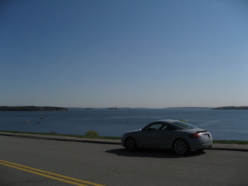
Made it to Portland on Monday after a short drive from Tewksbury, MA. Seemed like a nice town but I rolled out after a few quick pictures at the waterfront. 5223 miles from Portland to Portland :) From Portland I headed west on 25, 16, 28, 202, 9 and 7 to get back to I-87 and head south to Kingston. I'll be here for the rest of the week taking a break from driving and standing up as much as possible :) I roll out of here the 19th heading to NC for a pilgrimage to the Modshack. From there I turn west and begin the scenic journey home, still close to 3 more weeks on the road.
Trip Stats:
415 miles
8hrs of driving
53mph average speed
31mpg
18k ft climbed
one stop for gas
Sunday, May 13, 2007
The long haul
Today was the last high mileage day for awhile and it was the longest of the trip so far. I knew Portland would be out of reach, mapquest said it was 820+ from Fremont where I spent last night. I did make it most of the way through Massachusetts today though so I'm about an hour and a half from Portland. From there it'll be a scenic drive through Maine, New Hampshire and Vermont back to NY and a few days of down time (yay!) For those keeping score at home, the TT had racked up over 5000 miles on the trip, the front bumper is.... colorful.
Trip Stats:
775 miles
12hrs of driving
65mph average speed
30mpg
19k ft climbed
two gas stops
Trip Stats:
775 miles
12hrs of driving
65mph average speed
30mpg
19k ft climbed
two gas stops
Saturday, May 12, 2007
I hate Indiana
I was thrilled to get out of Illinois and into Indiana but that didn't last very long. My last trip through Indiana resulted in a visit from the State Police so I was hoping to avoid that today by setting the cruise at ~6 over until I got to Ohio. Shortly after stopping for dinner I started getting radar hits, no worries I though, I'm in the right lane minding my own business and both the speedometer and GPS are reading 76mph. In fact there was a minivan ahead that was doing at least 85 and I had a cluster of cars behind me that were gaining on me and about to pass. So, I continued on my way past officer friendly partially hidden in the median. As the two cars behind me passed him he started to roll and I figured he was after the gold buick that had been steadily gaining on me but nope, he tucked in behind me and the lights came on. He tells me he was pulling me over for speeding, 83 in a 70 he says. I was shocked since I had been holding a steady 76 since I pulled out of the rest stop (I checked the GPS log, ~76mph for 30 straight minutes). He would hear nothing of it though, both my speedometer and GPS were wrong (by the same amount), oh and the GPS is a dangerous distraction. He is a highly trained officer and not only did he get me on radar but he is trained to visually check speed and was sure that I was doing 83mph. My questions only got me a lecture, I was getting the buick's ticket and there wasn't much I could do about that, he owes me $136.
It is very unlikely that I will ever make this drive again. There's not really much to see on this side of the country, all the interesting stuff is on the west coast. Driving this far is really just for the drive and the bad drivers, bad roads, tolls, police and traffic take all the fun out of the drive. I've driven close to 4000 interstate miles in the past week and I didn't see a static speed trap until I got to Indiana, in Wyoming and Montana the State Patrol actually patrols! They're not parked making money for the state on a poorly maintained toll road. The drivers in Illinois have the worst lane discipline I've ever seen, even worse than SLC. I will be glad to at least get out of the northeast, I'm hoping things are better in the southeast but don't expect to really get back to motoring until I get back to New Mexico.
I did make it about a third of the way across Ohio today. Tomorrow I will either head towards Portland or make a pitstop in Kingston, it'll depend on what time I hit Albany and how tired I am. No more timezones to cross so at least I won't lose an hour of driving tomorrow.
Trip Stats:
664 miles
10hrs of driving
68mph average speed
29mpg
11k ft climbed
two gas stops
5 states traversed; Minnesota, Wisconsin, Illinois, Indiana and Ohio
Friday, May 11, 2007
Greetings from Minnesota
Today was another long driving day but with some scenic detours along the way. Devil's Tower was only a short detour from I-90 up Hwy 14 and I missed it last time I was through here so I made a quick pitstop. Hwy14 was a great twisty backroad and at that hour there was almost no traffic so I took advantage of it as much as possible. Gotta keep the average mph up :) I spent about an hour at the park walking around and taking pictures. I thought that Devil's Tower was basically just the remaining core of a volcano that had eroded away. That's not quite right, the core itself was buried at least a mile underground. So when you're standing at the base of the tower you're actually standing a mile underground, well you would have been a few million years ago. Impressive stuff.
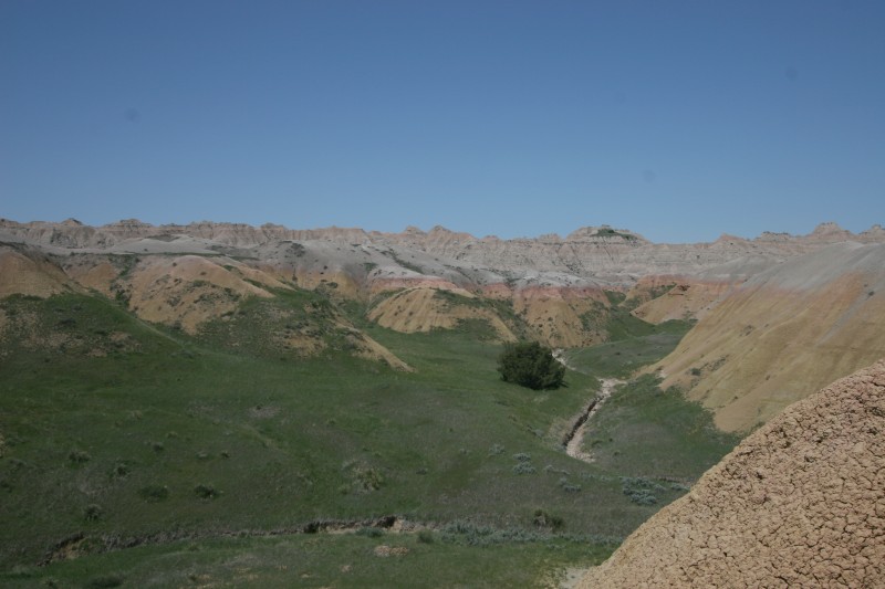
Back on 90 I quickly passed into South Dakota, land of the billboard. South Dakota could actually be a pretty scenic state if you could see past the billboards. There are eleventy billion of them for Wall Drug alone. Oh and the reptile farm. And anything else that might just be 200 miles down the road. I hopped off 90 to take Hwy240, the Badlands loop. I had been there in 2003 and was glad to finally get another pass through the park. There were a few places that I remembered from last time that I couldn't find today. I doubt the park has changed so maybe they were off of a side road. This ended up being a 2hr detour with quite a bit of walking and hiking. The weather was perfect all day although it is starting to get warm, temps in the 80s instead of the 40s we had in the Tetons.
I was back on 90 at 1:30 and hadn't really made alot of progress so far, I was hoping to make it halfway across Minnesota before stopping so it was time to crank the cruise up and roll. There seems to be a bit more enforcement in SD than Montana and Wyoming, I actually saw some police cars today. People tend to cruise at higher speeds in SD too. In Wyoming/Montana I was blowing past most people with the cruise set at 82mph but in SD I was just creeping by. Late afternoon I was just about to the Minnesota border so I stopped for food and gas in Sioux Falls. From there it was only about 180 miles to Albert Lea in Minnesota which is where I was hoping to make it today. I finally rolled in at 8:30, well 7:30 but I lost an hour when I rolled through the central time zone. Speed limits are down to 70 in Minnesota. I'm going to miss the big western states for the scenery and sheer cruisability. I imagine things will get slower as I get further east. Minnesota is pretty nice though. Lots of farm country along 90 with farmhouses tucked into trees. Quite picturesque with the sun setting in the background. Tomorrow will hopefully be a multi-state day, I'm hoping to be in Toledo tomorrow evening.
Trip Stats:
700 miles
9.5hrs of driving
73mph average speed
26mpg
16k ft climbed
two gas stops
Thursday, May 10, 2007
Motoring.
Russ headed out early enough this morning that I didn't even hear him leave so now I'm flying solo. I hit the road around 7am and made a quick stop at the local Kalispell Napa. The TT uses some oil and I brought a spare quart but that won't last long with the mileage I'll be doing this week.
After stocking up I headed south on Hwy93 down to I-90 at Missoula. It's a nice drive around Flathead Lake but there are several towns and slowdowns in the way. Once I made it to I-90 I was able to set the autopilot and just cruise. There were some pretty good storms east of Missoula, hail and very heavy rain. My new BKM for dealing with weather is to drive faster. As I made if over the mountain passes the skies cleared and it was great driving weather. I stopped off in Bozeman around noon for lunch and gas and eventually made it all the way out to Gillette in Wyoming around 5pm. Montana is really big. I was tempted to continue on to South Dakota but I'm hoping to stop at Devil's Tower tomorrow which is about 20 miles inside of Wyoming.
Trip Stats:
700 miles
9hrs of driving
76mph average speed
26mpg
23k ft climbed
two gas stops
Totals so far:
3029 miles
90 gallons of gas
Glaciers
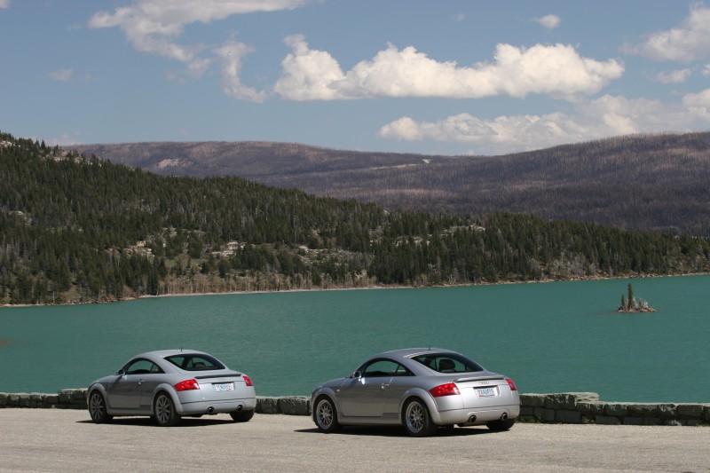
I forgot to mention that last night while washing the cars we had a local guy talking to us about the cars and he had us stay put while he got his camera to take a couple pics of the TTs. I have a feeling they don't see very many of them out here. They've got a ton of Audis in Jackson Hole but otherwise German cars are pretty rare.
Anyway, we ventured from Great Falls further northwest to East Glacier and then up to Babb. There's a park entrance at Babb that leads into the Many Glacier Lodge. The drive in is a bit rough and the lake is actually a dam and the water level is pretty low. But, the view at the lodge is spectacular and well worth the visit. There was a boat ramp leading down to the lake so we took advantage of it and parked the TTs there for a few pics.
From there we headed back south to East Glacier and into the main entrance of the park which leads to the Going to the Sun road. The pass is closed for construction but you can still drive several miles into the park. The views along the lake keep getting better and better all the way up so we of course stopped several times for pics along the way. We had hotel reservations in Kalispell over on the west side of the park so we started in that direction. Since the pass is closed that means driving around the south side of the park to West Glacier. Russ and I had done this drive last year so we were both looking forward to it. It's not the twistiest stretch of road but it's still one of my favorite drives ever. It's worth doing this drive in addition to the Going to the Sun drive.
It was still pretty early so we decided to head into the park at West Glacier instead of waiting until tomorrow. This is the other end of the Going to the Sun road but the park on this side is slightly different. The lakes on the east side of the park are a deep turquoise but the west side are very clear blue. Great views all the way in and out and a most impressive waterfall/cascade about halfway up. I was finally able to get the tripod out and do a few long exposure shots, a few of them came out decent, I still need to work on my technique a bit.
We finally made it into Kalispell about 8pm and grabbed dinner and checked in. Since we were able to cover so much ground today we'll be parting company on Thursday and Russ will head for home and I continue east. It's been a fun week and Russ has been a great tour guide along the way. So, since I won't have another TT to take pictures of I'll probably have to start stalking Camrys for on-road pics :)
Pics from Glacier
Trip Stats:
415 miles
8hrs of driving
54mph average speed
29mpg
17k ft climbed
two stops for gas
Tuesday, May 8, 2007
Going the wrong way

Today was a transit day relocating from southern Montana to the north. Hwy78 out of Red Lodge turned out to be a good choice, lots of turns that opened up with a view of the road stretching out through the valley. It was great right up until the 9 miles of construction with the road torn down to ruts and gravel. It seems in Montana that they don't do road construction is small chunks, they just go ahead and rip up the entire thing. That's ok, got to use quattro a bit getting through some of the deeper mud and gravel. From Columbus we cruised down 90 to Hwy287 to take a short cut up to 15. 15 follows the Missouri river and has some fun sections twisting along the river and through the valleys. We rolled into Great Falls early afternoon and found a coin-up car wash place. $4 later the TT is clean again and the weather forecast looks clear for at least a few days so it will hopefully stay clean. Tomorrow we're off to Glacier.
Tuesday pics
Trip Stats:
333 miles
5hrs of driving
68mph average speed
29mpg
9300 ft climbed
one stop for gas
Kills bugs. Dead.
Butterflies make the nastiest smears when they collide with a windshield traveling at a high rate of speed. And they've got these large bugs out here that hit like a small rock. But a quick coin-op wash tonight and the car is clean and happy again.
Monday, May 7, 2007
Best. Road. Ever.
Today was spent touring the local mountain passes and taking a ton of pictures. From Red Lodge there are two passes into Wyoming, the Bear Tooth Pass and the Chief Joseph Scenic Highway. The Bear Tooth is closed for a couple more weeks for snow clearing, I think the summit is about 10k ft. We were only able to get about 17 miles in on this side of the pass before we hit the barricade. The Chief Joseph Highway (Hwy296) is open though and the far end of it connects to the other end of the Bear Tooth so we could check that side out too... and Hwy 296 is the Best. Road. Ever. Last night we had a nearly clear run of Hwy296, 45 miles of very entertaining road and only had 2 cars in the way. The first run down it today was about the same, good times :) The Bear Tooth from the south is a fantastic stretch of road too, great views and alot of fun to drive. We stopped at the "Top of the World" because the road was getting down to single lane with deep snow on either side. One of these days we'll plan a trip later in the year when the whole pass is open. We did find a very cool waterfall fed by snow runoff but decided against hiking in to it.
So back the other direction we ran Hwy296 again back to Red Lodge but stopping for lots of pics this time. This time there was no one in our way but we stopped frequently anyway. Last time I was out here I had the G3 so I wanted to take advantage of the 20D and the 10-22mm lens on this trip. We got back to Red Lodge around 7pm and found the restaurant we ate at when we were here a couple years ago that has the best sweet potato fries on the planet.
Tomorrow we have a change of plans and we're going to head to Glacier instead of spending another day running the passes, we don't want to overstay our welcome ;) I don't think it will be very long before we're back out here anyway, hopefully with a yellow car.
Oh, and a PSA for the guys with the diesel pickup trucks. Your truck isn't fast, you are in our way, and you aren't going to keep up with us. Thanks.
Even more pics today
Trip Stats:
251 miles
4hrs of driving
54mph average speed
21mpg
19k ft climbed
one gas stop
Sunday, May 6, 2007
Sunday Sunday Sunday!!
 This morning we finally had blue sky and no new snow on the ground. It was still windy and cold but I was thrilled to see the sun, it was starting to feel like Portland. We headed out of Dornan's about 10am and headed north through the park on the way to Yellowstone. We planned to run up the west side of Yellowstone and around to the northeast exit to get to the Chief Joseph Scenic Highway and then over to Red Lodge in Montana. We stopped off at Signal Mountain in the Tetons and got to a great photo spot about halfway up the mountain. Eventually I was tired out from running up and down the hill (at over 6k ft) so we headed back down and continued out of the park. Russ had remembered a campsite that had access to the lake and great views of the Tetons so we planned on stopping there. It's great traveling with someone who has local knowledge of pretty much the entire west side of the US, you avoid all of the usual scenic viewpoints and stop at less well known ones, better pics and a more interesting trip. Anyway we found the campsite and hiked in to the lake and it was as promised, great views of the mountains. We decided it'd be alot more fun to hike back up to the road instead of heading back to the campsite. This of course presented a challenge because we couldn't just walk along the lake since there were several streams that fed it that needed to be crossed. The first crossing was easy but the next couple we had to stack enough driftwood to build a bridge to span a decent 4ft stream. We finally made it back up to the road after some bridge building and bushwhacking through the thickets and with a ton of great pictures.
Back at the camp we ran into a bicyclist who informed us that the south entrance to Yellowstone was closed! That put a serious crimp in the plans so we had to backtrack all the way back through Jackson Hole, back over the pass, north past the west side of the Tetons and then into the park at West Yellowstone. It added about 2hrs to the drive but really it was well worth it. We motored through Yellowstone without stopping since we were so far behind schedule and wanted to get as much driving done during the day as possible. We finally made it out of the park and up to Hwy296, my favorite road on the planet. Except for two slow movers we had the entire 45 mile stretch to ourselves and it was fantastic! The first car we caught up to probably had a several minute head start on us and was quite surprised when we showed up in their rear view mirror :) We eventually rolled into Red Lodge around 9:30 this evening. Tomorrow we head up the Bear Tooth Pass and maybe back to Hwy 296. We'll be here for 2 or 3 more days so lots of playtime :)
Pics from today
Trip Stats:
414 miles
8hrs of driving
50mph average speed
29mpg
20757 ft climbed
one gas stop
More snow

Saturday we woke up to a dusting of snow at Dornan's and heavier snow in towards's town. We wanted to head over to Driggs on the west side of the Tetons to check out a hillclimb site but before we even made it halfway up the pass we had to turn back because of snow. I guess we were lucky we came in on Friday instead of Saturday, we would have had to take the long way around the south to get into Jackson Hole. But, since we were now stuck in Jackson Hole we decided to head back north up to Jenny Lake inside the park to get some winter pics of the Tetons. I've been there in the spring and late fall so this was new even though it was old. We didn't spend too much time out and about since it was so windy and cold and ended up back at Dornan's for a late lunch. In the evening we took the shortcut from Moose over to Teton Village to get dinner at Calico's, a great Italian restaurant. So between Bubbas and Calico we ate pretty well in Jackson Hole :) This was our last night in Jackson Hole, Saturday would be mostly a travel day.
pics from the 5th
Trip stats:
100 miles
2 and a half hours of drive time
54mph average speed
28mpg
4309ft climbed
Saturday, May 5, 2007
The Tetons

Friday we rolled out of Meridian headed for the Tetons. The weather through Idaho was fantastic and we covered the 400 miles with few problems. Just before the I-84/I-86 interchange we picked up a hitch hiker, YMEEE. She was one of those drivers that is unable to drive on their own so she latched onto us and paced us, even when we slowed below 50mph (in a 75) she slowed right with us. So I took a bunch of pictures before she broke off for Ogden :) The Jackson Pass was clear with dry pavement although there was certainly plenty of snow in the Tetons. We're staying at Dornan's just outside of the main park entrance and within walking distance to the Snake River. A much nicer place to crash for a few days than in town. We did venture into Jackson Hole to hit Bubbas for dinner, fantastic BBQ.
the pics
Trip stats:
394 miles
6 hours drive time
67mph average speed
28 mpg
16639ft gained
One gas stop
Thursday, May 3, 2007
Which six CDs would you want on a deserted island...
or on a full month road trip? I have an mp3 player wired into the car but it only has a 10GB capacity and at last count I have about 12GB of CDs. It's easy enough to weed out the CDs that I probably shouldn't have bought in the first place but there's still the question of what gets loaded into the 6-disc changer. This is the backup for when the battery dies on the mp3 player, or if road conditions don't permit the use of the mp3 player (it's not strapped down and tends to fly around under heavy cornering/braking).
I ended up with:
Quicksand - Slip/Manic Compression
This one is cheating a bit because both CDs fit on one disc. Great for hammering through twisties
Metric - Live It Out
Just recently discovered Metric and this is a fantastic CD, several great driving tunes
Tool - Lateralus
Great for making fast progress over long distances
Failure - Fantastic Planet
Probably my favorite CD, always good for cruising
Rammstein - Reise, Reise
German car needs German music
Explosions In The Sky - Those Who Tell the Truth Shall Die, Those Who Tell the Truth Shall Live Forever
Some great tracks for long distance cruising and the last track is reserved for a v-max run somewhere in Nevada
431 miles down, hopefully no more snow

Welcome to Idaho! :) The first day was a pretty short hop, home to Meridian, Idaho, about 6.5hrs. This is usually a pleasant and smooth drive but heading through the mountain passes in eastern Oregon, up around 4k ft I started getting into some pretty heavy snow. Thankfully there wasn't any accumulation when I was rolling through but it was some pretty good blizzard conditions for awhile. In quattro we trust :) Most of the rest of the drive was clear skies except for around Portland. The Gorge from The Dalles out to Walla Walla was beautiful. Idaho starts out pretty nice, speed limits up to 75mph, but then there's always lots of traffic around Boise. It should be pretty nice cruising heading out of town tomorrow though.
The only interesting car I spotted today was a C6 S6 which I saw before I got out of Hillsboro.
pics from today
Trip stats:
431 miles
6 hours 22 minutes drive time
68mph average speed
30 mpg
15325ft gained
One tank of gas
Wednesday, May 2, 2007
Last time it'll be this clean...

Of course there has to be a pre-roadtrip detailing fest even though the car will be completely covered in road grime within an hour of getting on the road since it'll be raining tomorrow. It is nice to at least start with a clean car though. I've got a bucket packed with the essentials in case I get a chance to detail along the way. A full complement of stuff from Detailer's Paradise, Prima Mystique, Slick and Hydro as well as Invisible Glass for the expected huge number of bugs that will be scraped from the windshield.
Next update will hopefully be from somewhere in Idaho.
Tuesday, May 1, 2007
Spares and Tools

An important consideration when taking a long road trip in a TT is spare parts and tools. In 2003 I had a breaker bar and torque wrench and that was it. This time I'm not quite dragging the tool chest behind me but I am better prepared. In addition to the tools below I'll also have all of the common spares: coilpacks, a MAF, and coolant temp sensor. I've also got a spare DV, ECU and headlight bulbs. Hopefully I won't need any of them but this will be about a full year of driving compressed into a month.
Subscribe to:
Posts (Atom)